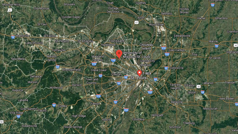
The newly renamed Geospatial Collaborative is championing research, technological innovation and community engagement that can support policymakers as they work to address problems facing residents across the St. Louis region. (Screenshot)
The University of Missouri–St. Louis continues to develop and expand its relationships with the growing geospatial ecosystem in St Louis.
The newly renamed Geospatial Collaborative is championing research, technological innovation and community engagement that can support policymakers as they work to address problems facing residents across the region.
 “My approach has been focused on making connections within the region and letting folks know we’re here and this is what we’re trying to do,” said Will Werner, an UMSL alumnus hired this spring to serve as the center’s director after almost nine years working as a planner with the St. Louis Metropolitan Police Department. “If you have problems that you think might fit or might be involved in the idea of spatial analysis, we might be able to help or we might be able to be involved with that.”
The center, launched in early 2020 as the National Security and Community Policy Collaborative, is operating out of space in the Geospatial Innovation Center on the fourth floor of nonprofit innovation and entrepreneur development facility T-REX. It will help facilitate connections with the National Geospatial-Intelligence Agency as it opens its new $1.7 billion campus just northwest of downtown and other geographic information system-related companies.
The original name didn’t clearly convey the center’s focus on geospatial intelligence.
“We want our partners to realize the breadth of UMSL’s research expertise on issues impacting national security, advanced technologies, critical infrastructure and community policy,” said Andrew Kersten, dean of UMSL’s College of Arts and Sciences. “The goal of the collaborative remains strengthening our communities through geospatial technology and tradecraft.”
Geospatial tools such as GIS allow people to capture, analyze and present geographical data in a way that can bring context and clarity to a problem.
“Data visualization is big regardless of whether it’s on a map or a bar graph or pie graph or Gantt chart, you name it,” Werner said. “I can’t even imagine how many books have been developed and written about how to visualize data and make it useful for people. The more that you can tell a good story with the data, the more useful and the better, more applicable that data can be to whatever problem or issue you’re trying to address.
“The goal is to present it in a way that makes it easily digestible for policymakers, for researchers, for the average citizen.”
The COVID-19 pandemic has provided plenty of opportunities to see its value with people getting in the habit of studying maps to see where cases of infection have been on the rise or which counties have been most successful distributing vaccines.
But GIS technology was already part of people’s everyday lives whether they realized it or not as they made use of an app to get directions to a new restaurant or tracked their latest workout.
“People integrate with that pretty regularly, but we are helping researchers in our university get access to those techniques,” Werner said. “There are a lot of interesting things that are going to happen regionally as NGA builds its footprint just north of downtown. There’s a lot of opportunity for involvement in some of the projects that they may be working on, bringing our researchers from UMSL to the table and having them participate and be partners there.
“Also, being in the T-REX building as that begins to start flourishing again and having more folks in and out of there with COVID restrictions relaxed – I think there’s a lot of opportunity to link up with some of the startups there and work in a research capacity.”