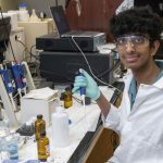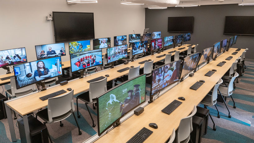
UMSL’s new GIS lab features 25 workstations outfitted with the latest GIS tools, including software such as ArcGIS, and connected to curved wide-screen monitors, ideal for displaying satellite images and other geospatial data. (Photos by Derick Holtmann)
The newly constructed Geospatial Advanced Technology Lab on the fourth floor of Benton Hall is nearly complete and will begin welcoming students and researchers from across the University of Missouri–St. Louis – and beyond – in the spring semester.
“This will be a hub for all research, training and geospatial workforce development on the UMSL campus and in St. Louis’ geospatial ecosystem, where we are leading the talent initiative working group within the GeoFutures coalition,” said Reda Amer, who has helped shepherd their development since taking over as the director of UMSL’s Geospatial Collaborative last February.
Recognizing the importance of developing talent to feed the region’s growing geospatial sector, the state of Missouri directed more than $1 million in funding through the MoExcels Workforce Initiative to establish the lab on campus. The university provided matching funds toward the project.
It includes GIS and virtual reality labs to serve students in all branches of geospatial science, including geographic information systems – or GIS – remote sensing, digital image processing and analysis, drone classes, spatial analysis, cartography, human geography, data visualization and GPS.
The lab features 25 workstations outfitted with the latest GIS technology, including high-powered Dell computers equipped with software from leading manufacturers such as Esri, makers of ArcGIS; NV5, which makes ENVI; Pix4D; and Trimble. Each one is connected to a curved wide-screen monitor, ideal for displaying satellite images and other geospatial data.
The room also includes interactive monitors and cameras to facilitate virtual learning and online classes.
Next door, there is also a virtual reality lab complete with eight headsets for viewing VR content, an interactive table, 3D and wide format printers and GPS stations that can be deployed in the field. The university has also invested in Spot, the agile mobile robot dog from Boston Dynamics, which is outfitted with infrared and laser sensors that can be deployed remotely to autonomously gather data in the field.
Amer said these tools can be used to support student learning even beyond the geospatial realm, including professors in chemistry or biology who might wish to show their students the interaction between atoms or molecules using VR technology.
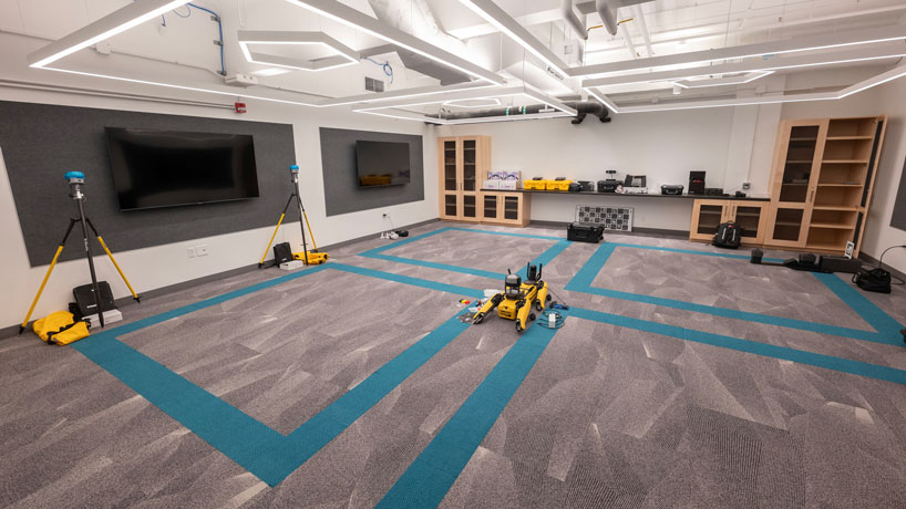
The virtual reality lab contains eight headsets for viewing VR content, an interactive table, 3D and wide format printers and GPS stations that can be deployed in the field, as well as Spot, the agile mobile robot, equipped with laser and infrared sensors.
“They can see exactly how the chemical reaction between atoms and molecules is happening at a microscopic level,” he said. “They’ll watch it through the headset instead of the atomic microscope.”
What’s more, there are applications for geospatial technology in a multitude of fields and industries – public health, national security, agriculture architecture, history, social science, biology, chemistry, geology, geography, and environmental science.
“This technology makes it easy for people in these disciplines to visualize and gain a better understanding for what they do,” Amer said. “Instead of just based on their imagination of what something looks like, I can see it, so I can make better decisions.”
He noted local nonprofit organizations such as Unleashing Potential, Gateway Global, The Little Bit Foundation, Rung for Women and St. Louis Community College who will be able to bring students and adults to UMSL’s labs to get training on the equipment.
It’s all part of the university’s commitment to help lead the collaborative K-16 talent initiative and geospatial workforce development while strengthening and expanding its partnerships.
UMSL has started offering a new undergraduate certificate program in GIS and has plans to develop graduate programs in GIS and geospatial science over the next few years.