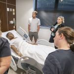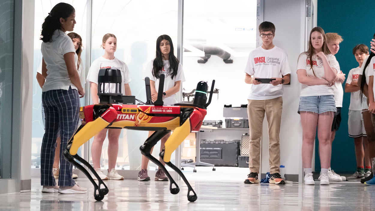
High school students take turns controlling Titan, an agile robotic dog, in Benton Hall at the University of Missouri–St. Louis Thursday afternoon. The 2025 Geospatial Science Summer Camp brought 22 high school students to campus for four days to introduce them to geospatial science and provide hands-on experience in various geospatial technologies. (Photos by Derik Holtmann)
Caleb Craig took the controls of Titan, an agile mobile robot dog, and confidently maneuvered the advanced robot through the fourth-floor hallway of Benton Hall at the University of Missouri–St. Louis.
Titan moved forward, backward and even up a set of stairs; raised itself on its haunches; and skirted onlookers in the hallway, all with the flick of a thumb. Craig looked like a seasoned professional controlling Titan Thursday afternoon, but it was the high schooler’s first time interacting with the cutting-edge technology.
He credited his success to the intuitive controls and his experience competing with his high school robotics team in Marine Advanced Technology Education competitions.
“It was just amazing,” Craig said. “It was great that I was able to experience this, because you can’t do that in many other places. You can’t just rent something like this, and it’s amazing that UMSL has this and you’re able to do this. It’s amazing. I love this program. I love learning all the things they do here on geospatial.”
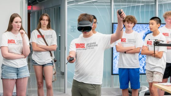
Meanwhile, Lucie Wildman, a rising sophomore at Lutheran South High School, and Shreya Sadhale, a rising senior at Parkway Central High School, had their feet planted solidly in the Geospatial Advanced Technology Lab, yet they were simultaneously worlds away. The two used Google Map Tiles – high-resolution, immersive 3D maps – and virtual reality headsets to explore cities across the globe and renowned landmarks such as San Francisco’s Golden Gate Bridge.
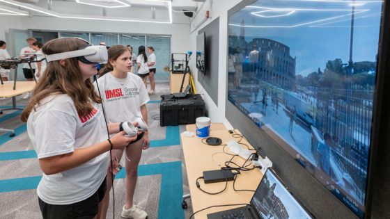
Sari Gross (left) and Samantha Cohen (right) try the virtual reality equipment in the Geospatial Advanced Technology Lab. Students explored destinations across the globe with VR headsets and high-resolution, immersive 3D maps.
Craig, Sadhale and Wildman were three of the 22 students from more than 20 high schools who attended UMSL’s third annual Geospatial Science Summer Camp. The camp, held over four days last week, was organized by UMSL’s Geospatial Collaborative with the goal of exposing students to Geographic Information System tools. The Geospatial Collaborative also hosted a two-day camp the previous week for middle school students.
Gizelle Cota, an assistant teaching professor with the Geospatial Collaborative, noted that she hadn’t been exposed to GIS in high school and only became acquainted with it toward the end of her undergraduate program. Cota said the camp aims to give high school students a head start in a growing industry that is increasingly centered in the St. Louis region.
“I think the objective is exposure, getting them excited about the field, getting them excited about geospatial,” she said. “St. Louis is where geospatial is going.”
Reda Amer, the director of the Geospatial Collaborative, concurred and explained that UMSL is actively building a geospatial talent pipeline within the local geospatial ecosystem.
“We’ve positioned UMSL as a leader of geospatial talent and a feeder for either advanced degrees in the field or the wide spectrum of careers in the field,” Amer said. “We have here the National Geospatial-Intelligence Agency, and they will have their new campus open this year. Also, we have the Taylor Geospatial Institute. They are our partner and collaborator, and we are a founding member of the institute. We now have students from the GIS program; they have internships and work on projects with people at NGA.”
Each of the first three days of camp, students heard from guest speakers in the geospatial field, including an official from NGA and industry professionals from leading GIS-software companies such as Esri. After the morning speaker sessions, Cota instructed the students in the use of tools such as ArcGIS and satellite and multispectral imagery. She eased them into the hands-on work with a navigation challenge using GIS software.
“You’re doing that interactively, and you’re thinking spatially,” Cota said. “Benton Hall was their starting point. So, what is my next location? Is that the closest location? Is there another one closer to a highway that can minimize that time? I had 10 locations on there, and it was at an hour and 50 minutes. They got it down to an hour and 10 minutes.”
Gabe Apicelli used virtual reality equipment to explore the International Space Station.
The first thing Amer asks the students is what they know about the geospatial field and technology. Cota said only a handful of students had experience with tools like ArcGIS. Sadhale was one of the students who had some background with the technology.
“I’ve done a little bit of GIS,” she said. “I was doing this program through my high school called Spark! We had exposure to different fields and technology. We did geospatial as one unit, and we did a simulation where we had to figure out where people were in different parts of the world. That’s where I got exposure, and I was recommended this camp to learn more about it.”
Wildman was interested in the camp because she enjoys making maps and examining data from different areas of the world. Craig was familiar with the camp because his brother attended during a previous summer, and his uncle Jim Craig is the associate dean of the College of Arts and Sciences. Though Craig has roots in St. Louis, his family lives abroad in Singapore for his father’s job. But he spends every summer in Missouri, and the geospatial camp made this trip extra special.
“What stuck out to me is, since geospatial sciences are really based in St. Louis, you get to meet the leaders of it,” Crag said. “You get to meet the people who are in charge of these large agencies like the National Geospatial-Intelligence Agency, and you really see what you would do there.”
Craig, Sadhale and Wildman are all interested, at the very least, in taking geospatial courses when they get to college.
“I think that even if you aren’t really familiar with geospatial, and you just want to try something new, it’s good to give it a try,” Wildman said. “You might find out that you really like it, and it’s going to be really relevant in the future.”
For Amer, the camp is all about fostering those formative experiences and sparking students’ interest in the geospatial field.
“Every year, I get more excited about this,” he said. “When I see the students, the first thing I ask in the camp is, ‘What do you know about geospatial?’ Most of them, they don’t know much. But at the end, they find it very exciting, and they want to know more.”