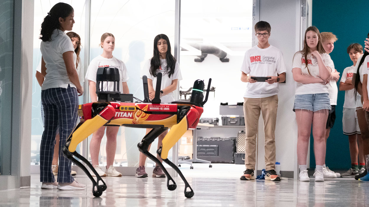
Local high school students learn to control Titan, UMSL’s agile robotic dog, during a recent geospatial summer camp. As part of a new workforce development program, UMSL is continuing to invest in opportunities like its annual summer camp to get more students invested in learning about geospatial. (Photos by Derik Holtmann)
Fortnite, Snapchat, DoorDash – for Frank Romo’s students, these are all ways that maps show up in their daily lives. As the founder of RomoGIS, a geospatial services company focused on community advancement and workforce development, Romo frequently travels the country teaching K-12, undergraduate and graduate students about geospatial tools and how they can be used for community impact.
For kids and adults alike, geospatial can be a difficult concept to grasp, so Romo starts by helping students understand where geospatial is relevant in their day-to-day lives.
“I think, too often, education is far removed from what students care about and what they experience every day,” Romo says. “It’s really easy to get into the weeds and talk about different technical things, but you’re going to lose students. For me, I start with what students are touching or seeing on a daily basis that is geospatial. It’s about meeting them where they are, understanding what is relevant to them and how geospatial relates to their everyday lives. Where do you get food from? How far away is that food? How do you get there? What does the transportation look like when you go to school? Is there snow on the route? All of these things are geospatial questions. It’s about helping them improve their geospatial literacy based upon the things that are impacting their lives.”
Fostering geospatial literacy and critical thinking from an early age is a goal not just of RomoGIS, but also of the University of Missouri–St. Louis, which has been contracted by the National Geospatial-Intelligence Agency on a new Geospatial Workforce Development Pilot Program. Involving local and regional partners such as RomoGIS, T-REX, GEO261 and Gateway Global, the project is designed to strengthen the nation’s geospatial workforce by building intentional education and career pathways that begin well before college. It reflects a shared understanding that workforce readiness is most effective when education, training and applied experience are intentionally aligned.
The initiative grew out of an idea that Reda Amer, director of the UMSL Geospatial Collaborative and principal investigator of the project, had when he first joined UMSL as director of the UMSL Geospatial Collaborative in 2023. He started thinking about ways to develop geospatial workforce pathways earlier and more effectively.
“Having worked in geospatial education and research for over 25 years, I had seen how late exposure often limits who enters the geospatial field,” says Amer. “I wanted to change that by connecting education, training and workforce with industry in a more intentional way. From my perspective, this program demonstrates how universities, when aligned with federal partners and supported by strong institutional leadership, can play a meaningful role in addressing national workforce challenges.”
From the beginning, the vision was well received and supported by leadership at UMSL and the University of Missouri System, as well as the broader geospatial ecosystem in St. Louis and partners at the United States Geospatial Intelligence Foundation. With that institutional backing, the initiative ultimately received federal support from Sen. Eric Schmitt, which enabled the program to be established as a federally supported pilot aligned with the Department of Defense in 2025. The goals of the project align closely with NGA’s mission to develop a sustained pipeline of geospatial talent, which is crucial for national security and infrastructure.
As the university partner for the $5 million pilot project, UMSL is leading the geospatial workforce development initiative, convening key players across the region to create a talent pipeline that will meet the growing demand for geospatial across a range of industries. The university is well-equipped for the task, offering an undergraduate GIS certificate and regularly hosting workshops, training and guest lectures designed to advance geospatial knowledge. UMSL is also unique in its multidisciplinary approach to geospatial education – rather than housing the geospatial program under one department, for instance, geospatial courses are available to students in all fields, from business to computer science to civil engineering.
The project aims to foster geospatial literacy and critical thinking from an early age through opportunities such as summer camps and workshops.
With that in mind, a major goal of the project is to grow the geospatial workforce by leveraging, developing, executing and sustaining geospatial education, training and certification. As part of the project, UMSL will expand its existing GIS undergraduate certificate, integrating a required capstone project and collaborating closely with NGA staff to enrich the certificate program’s content and instruction. One of the program’s central priorities is addressing a growing shortage of geomatics professionals – specialists trained in fields such as geodesy, photogrammetry, spatial data engineering and high-precision geospatial measurement. To help address this need, UMSL is developing a new undergraduate certificate in geomatics, which will prepare students in advanced geospatial data collection, spatial analysis, remote sensing and emerging AI-driven geospatial technologies. Courses in the geomatics certificate will be developed in collaboration with NGA experts, covering advanced domains that are critical to the NGA and intelligence community such as high- precision land surveying and spatial measurement techniques, global navigation satellite systems and geodetic modeling of Earth’s shape and gravity field.
The pilot program also strengthens UMSL’s role in advancing cutting-edge geospatial research. Through collaborations with the Taylor Geospatial Institute and other research partners, students have opportunities to participate in projects that combine geospatial science, artificial intelligence and large-scale data analysis.
UMSL will also expand access to its GIS certificate through dual enrollment with community colleges, flexible delivery and scheduling and noncredit certificates for veterans and active-duty personnel. In order to enable students across St. Louis to access geospatial coursework and participate in workforce initiatives, the project emphasizes a collaborative approach with other regional institutions including Harris-Stowe State University, Lindenwood University and Saint Louis University. Together, these institutions are expanding GIS certificate programs, shared courses, internships and research opportunities that allow students to gain practical experience while building pathways into the geospatial workforce.
UMSL’s existing introductory geospatial course, “GIS 1000: Geospatial Technology and Thinking,” will now be offered as a dual-credit course for high school students, enabling them to earn college credit and establish an early academic trajectory in geospatial science. But UMSL and its partners are also expanding access to geospatial education far beyond the university’s own campus. The university is designing a formal accredited GIS certificate program for high school students, enabling them to earn an industry-recognized credential prior to graduation. The secondary-level certificate, which will launch in 2027, will feature curriculum and assessment standards aligned with NGA and national geospatial competencies.
Through its work on the secondary certificate, UMSL is expanding its partnership with Gateway Global, a local tech-based education and workforce development organization focused on workforce strategy, public-private partnerships and ecosystem development. As part of the pilot project, Gateway Global will expand the number of its students enrolled in the UMSL Bridge Program, a free, year-round college preparatory initiative for St. Louis-area students and their families, to include students enrolled in high school GIS certificate programs.
With an eye toward workforce connectivity, Gateway Global founder, chair and CEO Zekita Armstrong is helping to ensure that what’s happening inside the classroom connects directly to what’s happening at NGA and across the broader geospatial ecosystem. She’s also identifying opportunities for internships and experiential learning and thinking through ways to build scalable talent pipelines. Gateway Global seeks to design pathways that connect youth and young adults to high-growth industries such as geospatial, and for Armstrong, opening that door early in students’ education is essential.
“Many students, especially at the high school level, don’t know what geospatial is or how broad the field really is,” Armstrong says. “If we wait until college to introduce students to these opportunities, we’ve already missed a critical window. Early exposure helps students connect STEM coursework to real-world applications. It also creates stronger economic mobility pathways. When students understand that there are high-wage, mission-driven careers right here in St. Louis tied to geospatial intelligence, it changes how they think about their future. Starting in high school helps us build a deeper, more diverse and more prepared pipeline.”
UMSL, Gateway Global and their other partners in the project also recognize the importance of getting secondary-level educators invested and excited about geospatial education. To that end, they’re facilitating quarterly geospatial workshops to strengthen STEM teaching by embedding geospatial technologies into math, physics and geography. Hosted across regional partner campuses including T-REX, UMSL, Lindenwood University and SLU to maximize accessibility and broaden regional participation, the workshops are designed to build teacher capacity, increase geospatial literacy and help diversify the student pipeline into GIS and GEOINT careers.
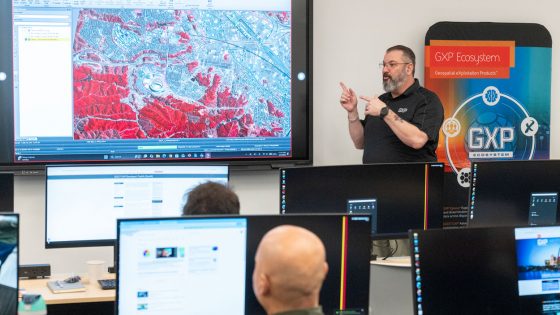
Jay Gordon with BAE Systems gives a geospatial presentation to UMSL faculty, staff and students during a workshop with the UMSL Geospatial Collaborative.
An introductory GIS workshop, held in February, taught high school educators core GIS ideas, such as spatial data, map layers and basic geographic analysis, and explored how GIS can strengthen spatial thinking, data literacy and real-world problem-solving across disciplines including social studies, science and mathematics. The goal was to prepare educators to begin integrating GIS into their classrooms and identify ways to stay engaged through the UMSL Geospatial Collaborative. Romo, who helped develop the secondary-level geospatial certificate and will be facilitating a few of the educator workshops, says his goal is to set the educators up to be the best resource possible for their students by equipping them with the necessary hard skills and helping them feel more confident in their ability to deliver that content to students.
“Whatever educators can do to help their students, they will,” Romo says. “So, for me it’s just about equipping them, upskilling them, providing myself as a resource and connecting them with the greater geospatial community so that they have more access to resources. One educator in isolation is only going to be able to do so much, but when we have educators who are connected with one another, who are supporting one another and who feel like they have support at the collegiate level or from industry-related partners, they don’t feel like they have to do it all on their own. They feel like they’re part of something bigger. They’re part of a greater ecosystem.”
Much of the project builds on the work that the UMSL Geospatial Collaborative has been doing over the past few years, including the popular geospatial summer camps it’s hosted since 2023. Open to both local high school and middle school students, the camps introduce students to basic concepts of geospatial technology, including GIS, GPS, remote sensing and cartography, and offer practical, hands-on experience with geospatial tools and equipment such as ArcGIS and multispectral imagery. This summer, UMSL will once again host camps in partnership with RomoGIS and the UMSL Bridge Program to continue to strengthen the pipeline for students who are interested in advancing their geospatial knowledge.
Amer says students’ excitement builds as they learn how to fly a drone or control Titan, UMSL’s agile robotic dog. Most exciting, however, is when they start to unlock the ways that geospatial science shows up in their day- to-day lives.
“Students get excited because they start to realize that something they are doing every day is actually a science,” Amer says. “They use Google Maps or Google Earth to see something, and then they can do it themselves. Not only that, but they can create their own image and create their own map for the walking track they use every day or the bus station where they are taking the school bus every day. They learn how to fly a drone, and they take images, and then they stitch these photos together to create a 3D model for the building. They get very excited to learn more about this. I keep receiving emails from teachers and from students to ask when the camp will be this coming summer, and now we have many schools asking to organize a trip to our geospatial labs. They want to get their students to see this technology and to get exposure on this field now, not to wait until they come to college.”
Those early touchpoints with students are critical in helping them develop geospatial literacy and opening career pathways to the fast- growing field. From geospatial summer camps to secondary-level certificates to educator workshops, the pilot project is harnessing the expertise of stakeholders including NGA, UMSL and partner organizations such as Gateway Global and RomoGIS to create a comprehensive, multi-faceted approach to strengthening the geospatial ecosystem in St. Louis. Growing the geospatial workforce locally is critical in light of NGA’s new $1.7 billion campus in North St. Louis, which has also attracted other geospatial, technology and defense companies to the region. It will also have a far-reaching impact on the region for years to come.
“The more you can upskill yourself, the better position you can put yourself, your family and your community in,” Romo says. “A lot of students want to make a difference in the world. I’ve worked with students who’ve done work ranging from deforestation in the rainforest to the impacts of natural disasters in their neighborhood. These students have a very keen insight on what’s going on in their community, and our focus is on translating that knowledge into technical skills that can then be impactful in a range of careers.
“By teaching students spatial awareness and enforcing critical thinking, we really encourage them to not only become producers of data and technology but to also recognize the responsibility that they have to contribute to their communities or to contribute to the greater good. And by educating them early on, we are opening up all the pathways for them that are possible.
This story was originally published in the spring 2026 issue of UMSL Magazine. If you have a story idea for UMSL Magazine, email magazine@umsl.edu.